75-Ultra Tihiorace, 3500m positive altitude (06/06/2026 - 07/06/2026)

DELFI – TIHIO
DISTANCE: 75KM ASCENT: +3500
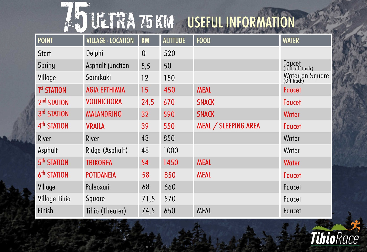
Delfi – Sernikaki – Ag. Efthymia – Vounihora– Malandrino – Vraila – Tihio
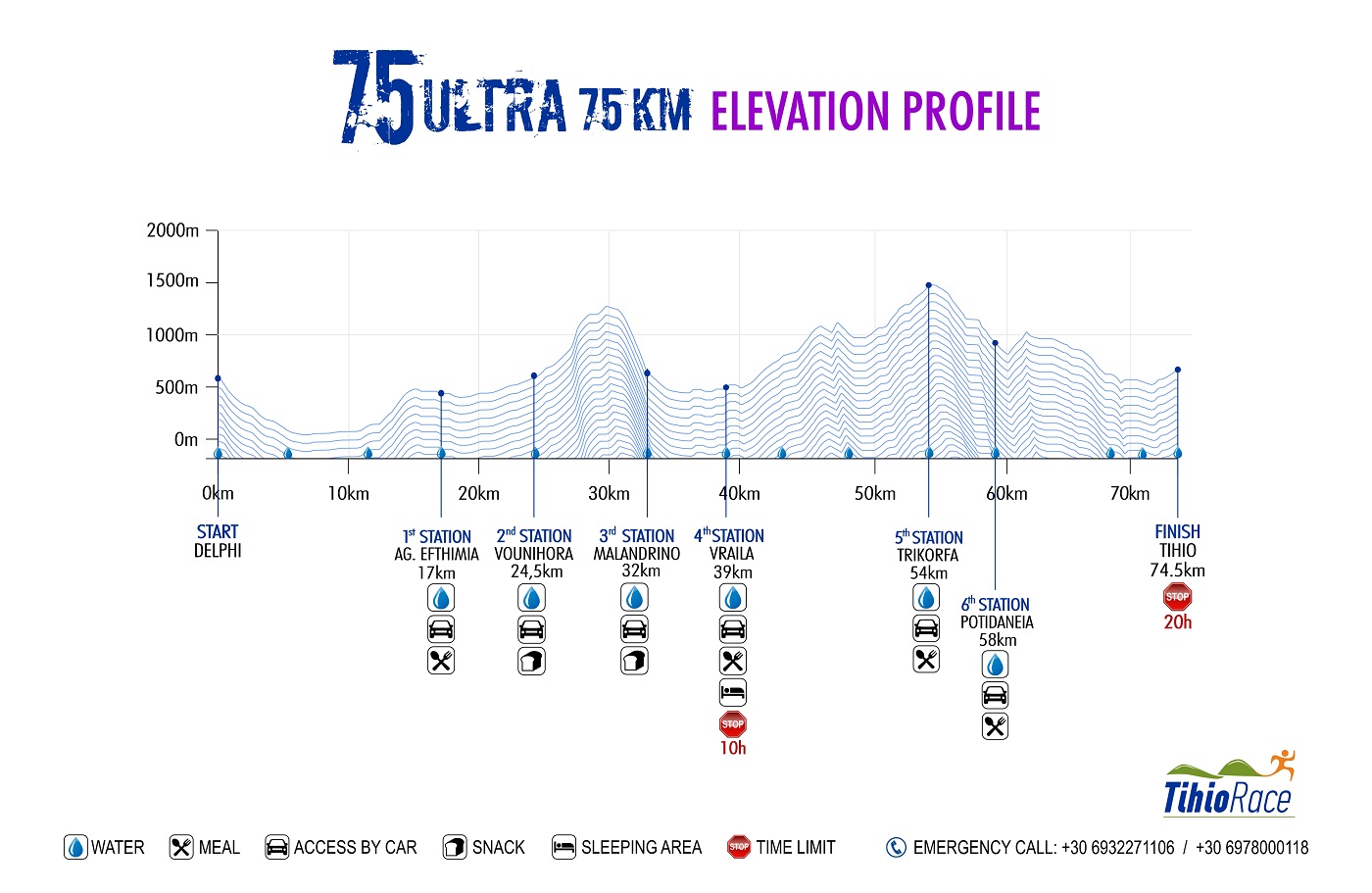
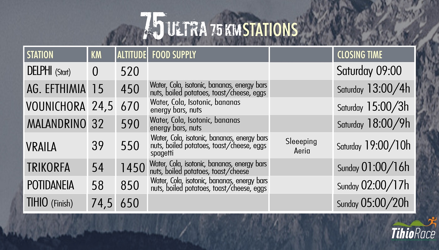
The route starts at the centre of Delfi village, where the E4 European long distance path crosses. From there, we will take the ancient path to Chrysso village. We will then go down a dirt path until we reach an olive grove, which is the place with the least elevation on our route (40m) (WATER FOUNTAIN). We will cross the olive grove through small tractor paths (used only for the harvest of olives). Attention is required at the 8th km, where we will use an underpass to cross the National Road of Itea-Amphissa. We will then run gradually uphill until we reach Sernikaki village at 11.5km. (WATER). From then on, an uphill footpath will take us to a vertical rise of rocks. The only pass is the well-known ‘Portes’, where we will cross over to the small meadow of Ag. Efthymia. The old trail has now become a small dirt road for the largest part, leading to the village of Ag. Efthymia (17km.) with a mild uphill slope. This is where we find the 1st aid station.

As we go down to the bottom of the village, crossing through a dirt road lined with dry stone right and left, we will find ourselves in ‘Gardiki’ meadow. Soon we will enter a creek through an almost flat footpath. We will then run along an asphalt road and at the 24th km we will reach the centre of Vounihora (WATER FOUNTAIN).
Here we begin a strenuous ascent to mount Kokkinari (part of mount Ghiona). We will follow the asphalt for 1km and, just past the last houses, will take a right to a small uphill rural road. We will go off that road after 1km to follow a trail inside a creek, where at times we will come across the dirt road. At the 30th km we will reach the highest point at 1310m. looking down to a breathtaking view at lake Mornos. We will then go down a small forest track, then on to a footpath. ATTENTION: From kilometre 31 to 32 lies the most technical trail of the route. The terrain is flimsy, therefore extra care is required when going down, as it is a relatively steep slope. As we come out to an asphalt road, we will take a right (towards the north) to reach the centre of Malandrino at the 32.5 marker, at a 600m elevation (WATER).
There follows an easy crossing through the meadow of Malandrino. After we go down to the meadow from the village, we will vertically cross the old National Road of Itea-Lidoriki. A small rural road will take us to a trail leading to the village of Vraila (338.5km. at a 550m. elevation). This is where we find the 2nd aid station
We will follow the asphalt for 1km downhill heading south. We will turn right (west) and head uphill on the dirt road. Ahead of us, two hills (Vouni and Aetovouni) are effectively “blocking” our route. In between is Vathyrema gorge. An impressive footpath has been carved into the south bank of the gorge, used in antiquity to access the mountains of Dorida. We run alongside the gorge (water is drinkable). We then take a right to head north, and will go up an uphill slog for 1 km to reach a dirt road. We will follow the dirt road for 1km more, then switch to a footpath that will take us up to an anonymous peak at 1178m. with a chapel that looks down to lake Mornos. We are now at the 47th km.
The descent from that peak is a beautiful trail leading to Bouhori Ridge above the villages of Milia and Stylia (at an altitude of 1000m.). This col has a beautiful view to all surrounding mountains and the sea of Eratini. This is the beginning of the final extended ascent of the race, that the amazing oak forest will definitely make up for. A mild dirt path will lead us to a dirt road. We will follow that dirt road, passing by the first wind turbine, only to get back on the footpath on a now alpine terrain. At the 55th km we are now at the top of mount Trikorfa, at an altitude of 1530m.(CHECKPOINT WITH WATER) An exquisite view to the high mountains of Roumeli (Ghiona, Vardousia) and the gulf of Corinth to the south, and the mountains of the Peloponnese (Helmos, Ziria, Erymanthos, Panachaiko).
A fantastic downhill trail through the fir trees will be a great opportunity to pick up speed for those who still feel up to it. A short uphill section leads to the chapel of Ag. Constantinos, then turns downward. Along the dirt road we will come to a cement water tank (59th km, 1054m. altitude) (drinkable water is available in portable containers).
At that point, we will turn right (west) to an undulating trail, running through a wonderful oak and pine forest. After 4km, we will come to a main dirt road. We will follow the marks on the trail right up to a cement water reservoir on the asphalt. We will then go down the asphalt road and pass through the village of Tihio (spring).
After 1km of mild uphill slope, we will reach “Theatraki” and cross the finish line, after 67 challenging but beautiful kilometres!
GPS ROUTE: https://el.wikiloc.com/