3 UltraSummits TihioRace 180Km, 11000m positive altitude (09/06/2027 - 12/06/2027)
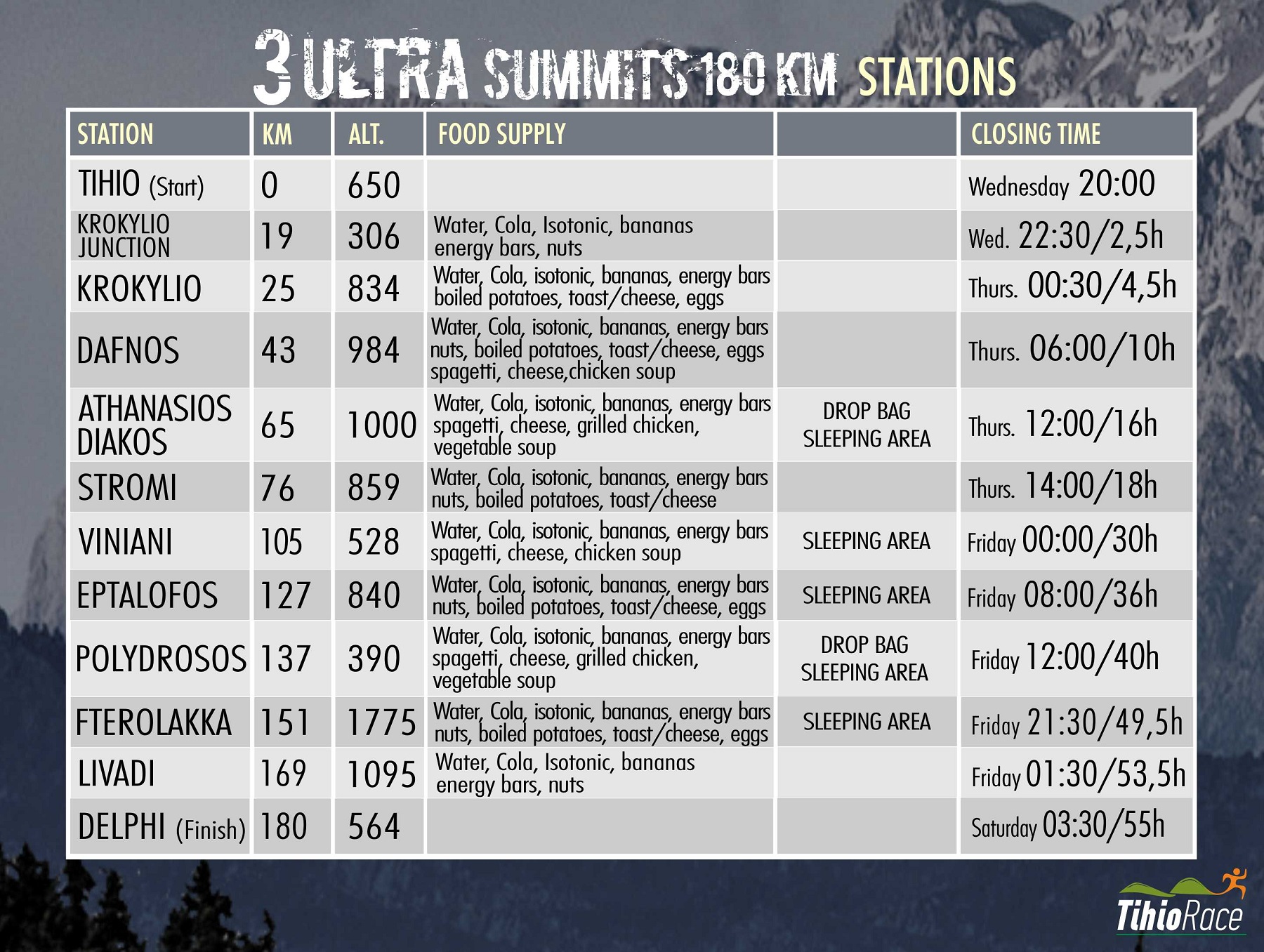
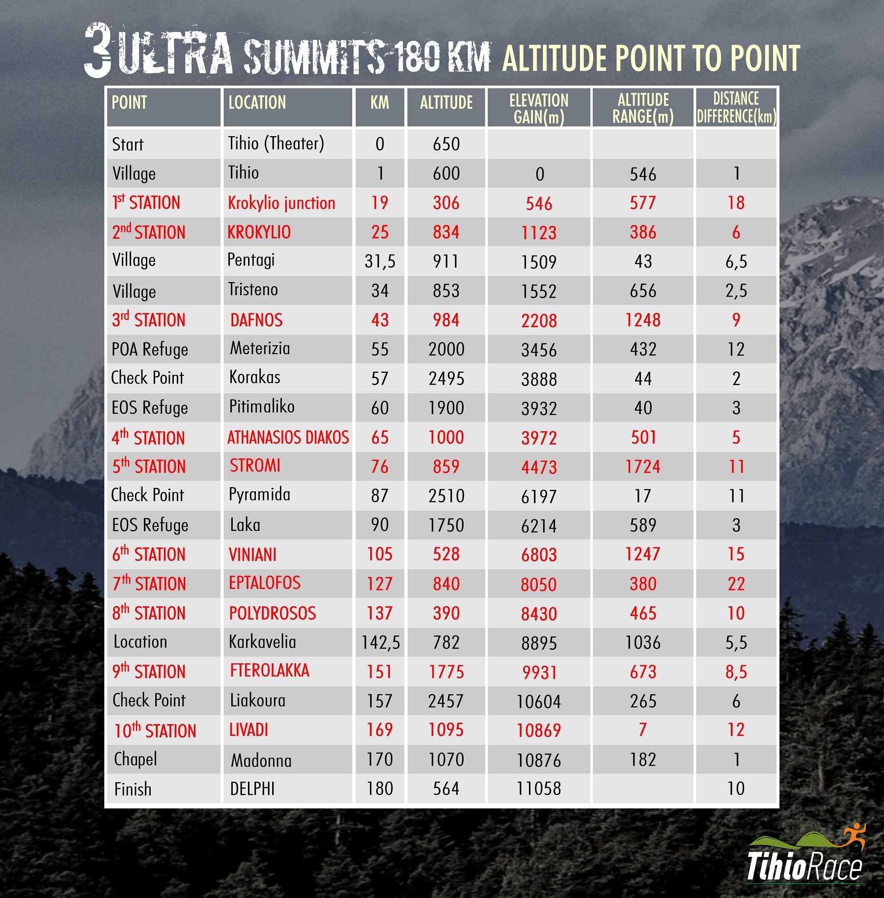
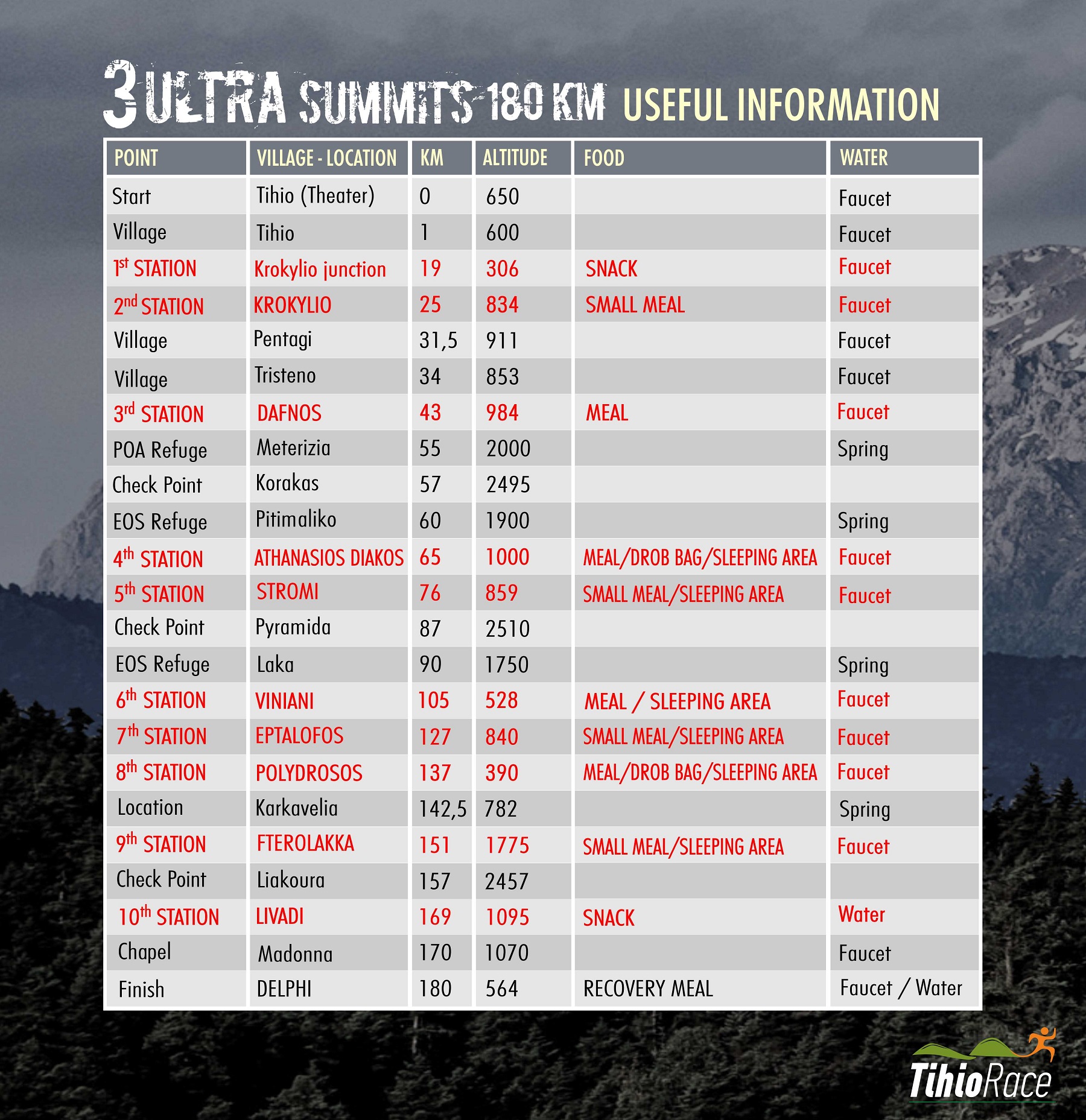
To run this race, one must be properly prepared both physically and mentally. The total elevation gain reaches nearly +11,000m, and the terrain is generally quite rocky with purely mountaineering trails. Furthermore, the philosophy of the race is semi-autonomy, although there are 10 aid stations (two of which are for drop bags) and 3 checkpoints. (A detailed table is provided at the end of the description).
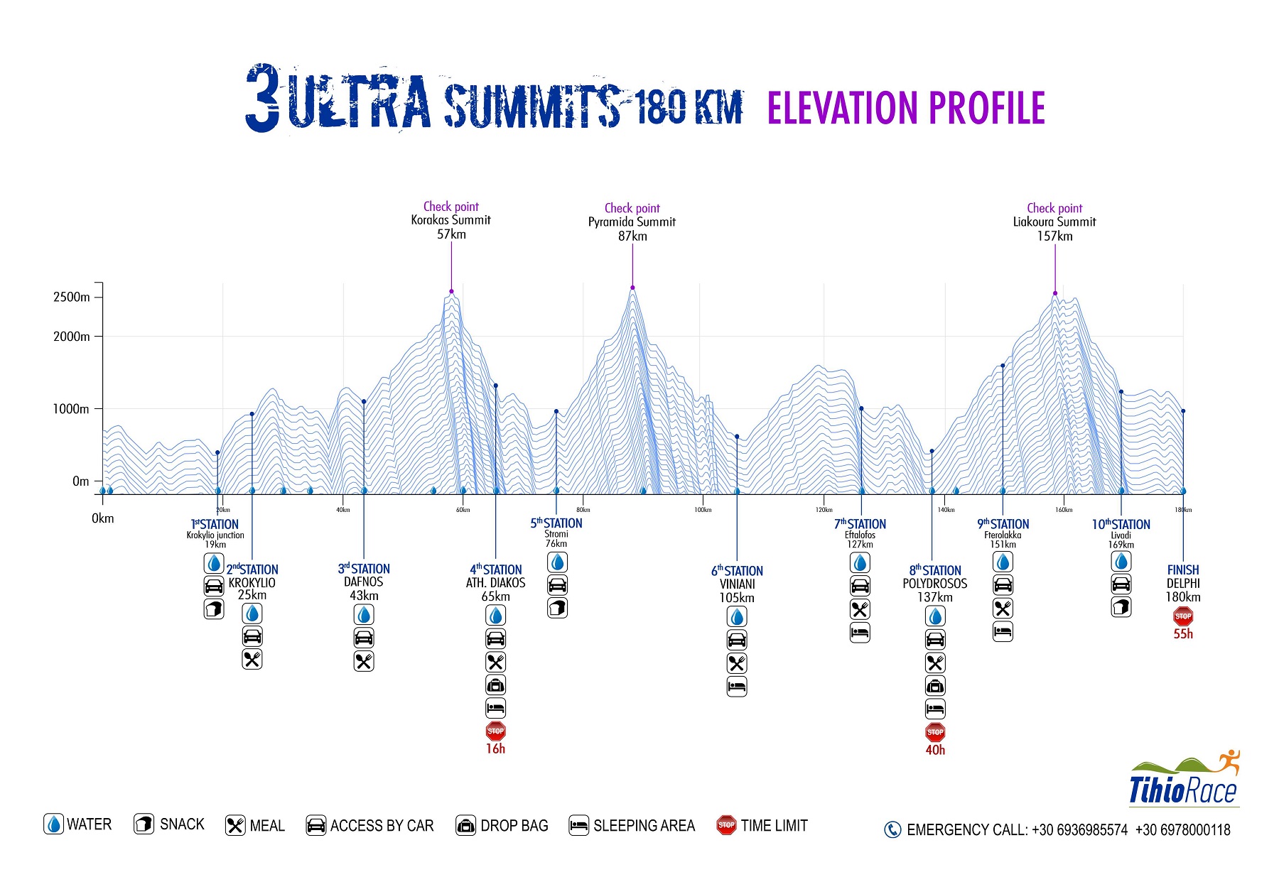
The race starts in the village of Tihio. Begin at the "Theatraki" (a small open-air theater) and head downhill along the asphalt road to the right, moving towards the village center, where water is available. After approximately three (3) kilometers, you will reach Paleoxari at the 3.2 km mark of the course, turn left (heading North) and follow a downhill dirt road that leads near the river (Mornos). There, follow a small dirt track—resembling a trail—heading east and running parallel to the river, moving upstream. At the 19 km mark, you will encounter a small paved road featuring the first station (Station 1) then turn left and descend towards the river. After crossing it, turn left onto the main paved road, where a water fountain is located. Next, ascend a trail, having crossed over to the opposite side (the northern slopes) of the river Mornos. Along the way, you will cross the paved road several times. Eventually, you will reach a dirt road that leads to the saddle above the village of Krokyleio. Finally, descend to the village square, where the second station (Station 2) is located at the 25 km mark.
Head uphill along a beautiful trail through a ravine, following a route across old meadows that keeps us on a safe path. After 1 km, leave the trail to join a dirt road leading to a small chapel. There, pick up a downhill trail through the fir trees that leads to the village of Pentagioi (31.5 km, water available). The next 3.5 kilometers to the village of Tristeno (34 km, water available) follow a safe route while offering panoramic views of the entire southern ridge of the Vardousia Mountains. At the edge of the village (near the church), take the path leading down to the Kokkinos River, where old watermills are located. Cross to the opposite (eastern) bank—wading through the water, as the iron bridge is no longer safe—and begin to ascend. A beautiful forest leads to the village of Dafnos, marking the 43 km point and the third station with hot food available (Station 3).
From Dafnos, follow the uphill dirt roads that leads to the Meterizia saddle. Caution is required here: you must not head toward the Vardousia mountain refuges visible downhill ahead; instead, you must ascend toward the summit. Water is available at a rock formation here (55km). Carefully make your way up to Megas Kampos, cross it, and reach the highest peak, Korakas (2,495m) with the 1st check point. Descend via the same route back to Meterizia and then head downhill toward the refuges. Pick up the trail, which winds its way to the pass of Profitis Ilias. Continue along a steeper incline (a slippery section) and reach the village of Athanasios Diakos (Mousounitsa) at the 65th kilometer. This is the location of the fourth aid station (Station 4)—featuring the race's first drop bag—situated in the village square at an altitude of 1,000 meters.
Leaving the square, follow a safe uphill road leading out of the village. As the descent begins, turn left onto the E4 trail, which leads down to the river (Mornos). After crossing the bridge, run along a dirt road and then follow a trail that brings you to an asphalt road. Follow this road until Stromi (76th km), where the fifth aid station (Station 5) is located. Here, it is essential to fully resupply, as the massive ascent of Mount Giona follows—marking the wildest and most isolated section of the race.
Follow the E4 trail uphill and, at the 78.5-kilometer mark, join a dirt road. At the 80th kilometer, turn right, and after one kilometer (at a crossroads), bear left, heading uphill toward the Meyer’s Cave. It is worth noting that you are passing by the historic cave where the British saboteurs of the Gorgopotamos operation hid in 1944.
Cut across the switchbacks of the dirt road by following an old uphill path. After the 85th kilometer, enter a rugged trail that leads to the famous Vathia Laka. Ahead lies the sheer, 400-meter rock face of Pyramida, which the trail skirts from the east. At the 86th kilometer, you will reach the saddle between Platyvouna and Pyramida. Extra caution is required here, as you must ascend to the summit and then return to this exact spot to head south toward the Giona Refuge.
Ascending from the saddle, the paths becomes more technical and mountaineering in nature—meaning there is no distinct trail, so follow the markers instead. At the second peak, Pyramida (2,510m), there is the 2nd checkpoint, and the view is highly rewarding, with peaks ranging from Olympus to Taygetos all being visible. Reach the 87km mark, where a long, grueling 15km descent begins. Descend to the saddle and turn right (south), passing in front of the mountain refuge at the 90km mark. Next, enter the famous Reka Gorge. Here, the path is not always obvious, so you must follow the markers closely. The terrain is rugged; upon reaching the bottom of the ravine, navigate over large river stones, following the streambed toward the exit. Finally, you will arrive at the village of Viniani (105km), the location of the sixth aid station with hot food and beds available (Station 6).
From Viniani, follow the uphill dirt road that leads to the Lamia–Amfissa provincial road. Head towards Lamia (running north along a side road) and, after 200 meters, cross the main road to take an uphill path heading east. After 2 km, pick up the E4 trail and follow it eastwards. Alternating between a footpath and a dirt road, the route leads to the 116 km mark, near the Kokkinovrachos peak. From there, a continuous, steep descent begins, leading to the village of Agoriani. At the 127 km mark (altitude 840 m), there is a water source in the village square, which serves as the seventh aid station (Station 7).
From here, follow the trail "22," which initially heads east, undulating with rolling climbs and descents. After passing the Kitios peak (960 m), turn north and begin a continuous descent. ATTENTION: Although the descent gradient is gentle, the terrain is dangerously rocky. At the 133 km mark, you will reach the Kifisos Springs, an archaeological site featuring abundant running water, then follow the road for 2 km to reach the village of Polydrosos (altitude 390 m). Here, at the 137 km mark, is a main aid station (Station 8) containing the second drop bag.
National Trail 22 offers a beautiful dirt-track ascent through the fir trees, leading to the Parnassos Ski Center—specifically the upper chalet at Fterolakka (km 151)—where the ninth aid station (Station 9) is located. A dirt road followed by a trail leads to the base of the Liakoura cone (known as Lykoreia in antiquity). The ascent to the third peak, Liakoura (2,457 m, at kilometer 157), follows the same path used for the descent. After returning to the base of the cone, the route continues west along a somewhat faint path toward Gerontovrachos, which, at 2,367 m, is the second-highest peak. The view from here is equally impressive, looking south toward the Gulf of Itea.
The descent initially heads north before eventually turning west, approaching the small ski center owned by the Athens Club. After passing it, descend toward the tenth station at Livadi (169 km), where (Station 10) is located at the junction with the paved road. From there, follow the dirt road on the opposite side, heading west toward the Forest Outpost (situated below the Korykeion Andron cave). Next, a gently descending dirt path begins. At the 173.5 km mark, you will hit an ancient stone-paved trail; it is quite wide and offers views of the Delphi archaeological site (177 km). Also impressive is the view towards the valley of the Pleistos river with its olive groves stretching all the way to the sea. In the center of Delphi, on the southwestern slope of Mount Parnassus where the E4 European long-distance path also passes, we will reach the Finish Line after 180 tiring yet enjoyable kilometers.
A central station awaits you in Delphi, featuring a recovery meal, a rest area, welcoming volunteers, and an organization vehicle for your return back to Tichio. Those of you who wish to enjoy the traditional settlement along with the Archaeological site and stay in Delphi with its picturesque hotels and taverns, simply inform the organization.