4 Ultra Summits Tihiorace 310Km, 16000m positive altitude (09/06/2027 - 13/06/2027)
TIHIO - VARDOUSIA - OITI - GIONA - PARNASSOS - DELPHI - TIHIO
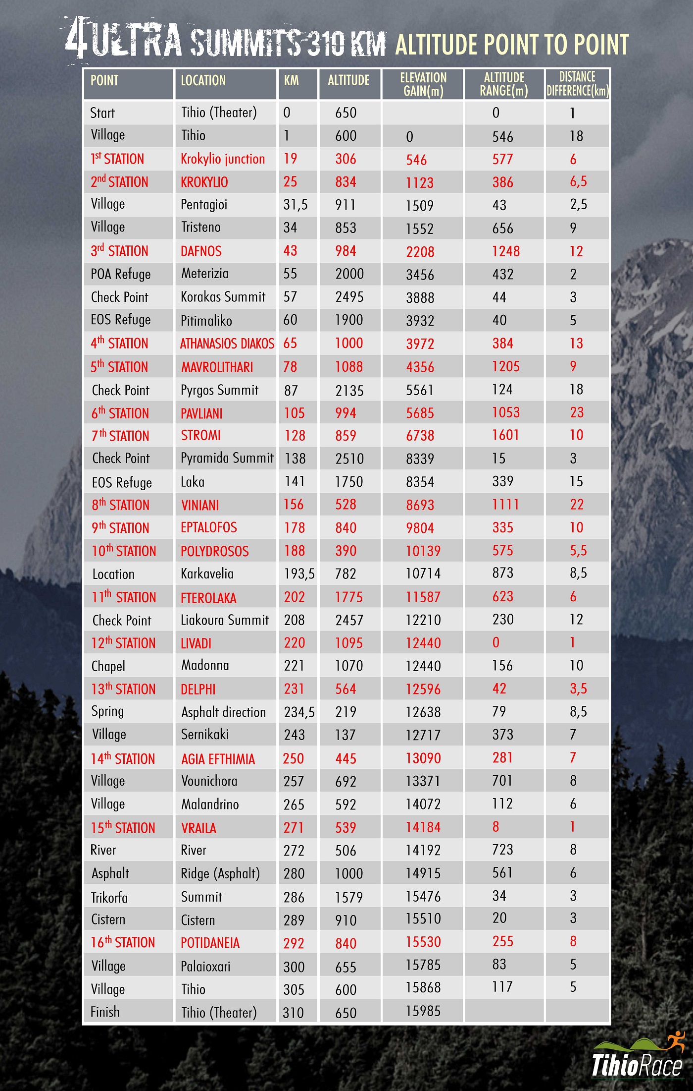
Tihio – Palioxari – Krokylio – Pentagioi – Tristeno - Dafnos – Korakas (Vardousia Summit 2495m) – Ath. Diakos – Mavrolithari – Pyrgos (Oiti Summit 2152m) – Pavliani - Stromi – Pyramida (Giona Summit 2510m) – Viniani – Eptalofos – Polydrosos – Ski Center Parnassos – Liakoura (Parnassos Summit 2457m) – Gerontovrachos – Livadi – Delphi – Sernikaki – Agia Efthimia – Vounichora – Malandrino – Vraila – Trikorfa – Potidaneia – Palaioxari - Tihio
Distance: 310 km
Elevation gain: 16,000 m
Mandatory equipment:
- Windproof/waterproof jacket
- Headlamp with extra batteries
- Emergency foil blanket
- Water containers with a total capacity of over 1 L
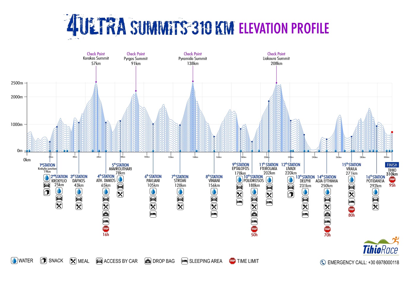
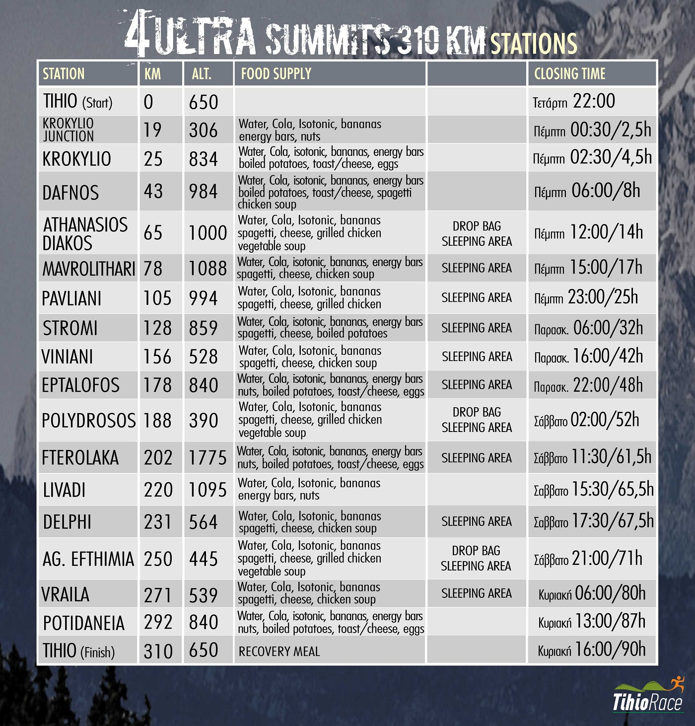
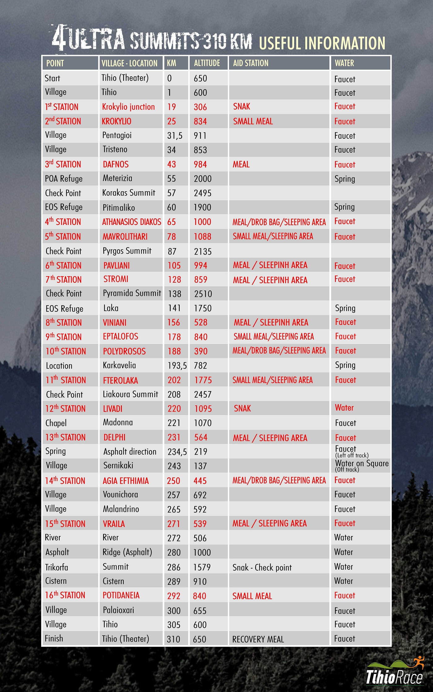
To participate in this race, one must be appropriately prepared, both physically and mentally. The total elevation gain reaches +16,000m, and the terrain is generally rocky. It is fair to say that there is no other race in Greece comparable in terms of such significant elevation gain and such challenging terrain. The trails can be described as strictly mountaineering-style paths. Furthermore, the race follows a semi-autonomous format, although there are 16 aid stations (three of which allow for drop bags) and 4 checkpoints. (A detailed table is provided at the end of the description.)
The start is located in the village of Tihio. We begin at the "Theatraki" (small open-air theater) and head downhill along the asphalt road to the right, towards the village (Tihio, where water is available). After approximately three (3) kilometers, we reach the village of Palioxari. At the 3.2 km mark of the route, we turn left (heading North) and follow a downhill dirt road that leads us down near the Mornos River. From there, we follow a narrow dirt track—resembling a trail—eastward, running parallel to the river (against the direction of the current). At the 19 km mark, we encounter a small asphalt road where the first aid/refreshment station (Station 1) is located; we then turn left and descend toward the Mornos River. We cross the river and turn left onto the main asphalt road, where there is a water fountain. We then ascend along a trail, having crossed to the opposite side (the northern slopes) of the Mornos. We cross the asphalt road several times along the way. Eventually, we reach a dirt road that leads us to the mountain pass above the village of Krokyleio. We then descend into the village square, where the second aid/refreshment station (Station 2) is located at the 25 km mark.
We head uphill along a beautiful path through a ravine, following a route across old meadows that leads us to an asphalt road. After 1 km, we leave the asphalt to join a dirt track, which takes us to a small chapel. From there, we take a downhill path lined with fir trees, leading to the village of Pentagioi (31.5 km, water available). The next 3.5 km follow an asphalt road to the village of Tristeno (34 km, water available), offering magnificent views of the entire southern ridgeline of the Vardousia mountains. At the edge of the village (near the church), we pick up a path that descends toward the river (Kokkinos), where old watermills are located. We cross to the other side—wading through the water, as the iron bridge is no longer safe—and begin our ascent on the eastern bank. A stunning forest leads us to the village of Dafnos, marking the 43rd kilometer and the third aid station offering hot food (Station 3).
From the village of Dafnos, follow the dirt road uphill, which will lead you to the Meterizia saddle. Be careful here: do not head toward the Vardousia mountain refuges, which you can see downhill in front of you. Instead, continue uphill toward the summit. There is also a water source located at a rock formation here (at the 55th km). Ascend with caution to reach Mega Kampos. Cross this plateau to arrive at the 1st summit, Korakas (2,495m). Retrace your steps back down to Meterizia, then descend toward the mountain refuges. Pick up the trail, which winds its way to the hill of Profitis Ilias. Continue along a steeper, potentially slippery section until you reach the village of Athanasios Diakos (Mousounitsa) at the 65th km. This is the fourth aid station (Station 4), located in the village square (at an altitude of 1,000m), where the race’s first drop bag is available.
We leave the square and follow an asphalt road going uphill outside the village. The descent begins and we turn left onto the E4 path. He takes us down to the river (Mornos) and we cross the opposite bridge. We run on a dirt road and then on a path that leads us to Mavrolithari (78km) where we meet the next station (Station 5) from there we start the climb to the second peak of the route and in 13km we reach the top of Oiti 2nd summit Pyrgos (2153m) at the 91st km. We descend from the path to Pavliani (105km) where the next station (Station 6). We run on a dirt road and then on a path that leads us to the asphalt. We follow it until Stromi (128th km) at the seventh station (Station 7). Here we must fully equip ourselves because the very long ascent of Giona will follow. This will also be the wildest and most isolated part of the race. We follow the E4 path uphill and at the 130th km we take the dirt road. At the 131st km we turn right and after 1 km. (crossroads) we go left uphill towards Meyer cave. It is worth mentioning here that we pass by the cave where the English saboteurs of Gorgopotamos were hiding in 1944. We cut the ribbons of the dirt road from an old uphill path. After the 136th km we now enter a hard path that will lead us to the famous Vathia Laka. In front of us is the vertical rocky slope (400m.) of the Pyramid. The path circles from the east. At the 137th km we reach the Platyvounas-Pyramidas pass. Be careful here because we will have to climb to the top and then return to this point to leave south to the Gionas Refuge.
Ascending from the saddle, the path is of a technical, mountaineering nature—meaning there is no distinct, well-trodden trail, so one must follow the waymarkers. At the 3rd summit, Pyramida (2,510m), there is a logbook to sign, and the view serves as a rewarding payoff; one can see all the mountains, stretching from Mount Olympus all the way to Taygetos. At the 138th kilometer, a long and arduous 15-kilometer descent begins. We head down toward the saddle and turn right (south), passing in front of the mountain refuge at the 141st kilometer. From there, we enter the renowned Reka Gorge. The path is not always clearly defined, so we continue to follow the waymarkers. The terrain is rugged; upon reaching the bottom of the ravine, we must navigate across river pebbles and boulders, following the streambed toward the exit. Finally, we arrive at the village of Viniani (156th kilometer), the location of the eighth checkpoint (Station 8).
From Viniani, we follow an uphill dirt road that leads to the Lamia–Amfissa provincial road. We head toward Lamia (northward, along a side road) and, after 200 meters, cross the road and turn east onto an uphill trail. After 2 kilometers, we join the E4 trail and follow it eastward. Alternating between trail and dirt road, the route leads us to the 167th kilometer, near the peak of Kokkinovrachos. From there, a continuous, steep descent begins, leading down to the village of Eptalofos. At the 178th kilometer (at an altitude of 840 meters), there is a water source in the village square, as well as the ninth aid station (Station 9).
From here, we follow trail "22," which initially heads east, alternating between ascents and descents. After the Kitios peak (960m), we turn north, entering a continuous descent. ATTENTION: Although the gradient of the descent may be gentle, the terrain is dangerously rocky. At the 184th kilometer, we reach the Kifisos Springs (an archaeological site featuring abundant flowing water). We follow the road for 2 km to arrive at the village of Polydrosos (altitude 390m). Here, at the 188th kilometer, is a main aid station (Station 10) where the second drop bag is located.
National Trail 22 offers a beautiful ascent along a dirt path through fir trees, leading to the Parnassos Ski Center—specifically the upper chalet at Fterolaka (202 km)—which serves as the eleventh aid station (Station 11). A dirt road, followed by a trail, leads to the base of the cone of Liakoura (known as Lykoria in antiquity). The ascent to the 4th summit, Liakoura (2,457m, 208km), follows the same path used for the descent. After returning to the base of the cone, we will continue westward along a rather indistinct path toward Gerontovrachos, which, at 2,367 meters, is the second-highest peak. The view is equally impressive, though it looks out toward the south and the Gulf of Itea.
The descent initially heads north, but eventually turns west as it approaches the small ski center belonging to the Athenian Club. After passing this, the route descends toward the twelfth station at Livadi, Arachova (120th km) this station (Station 12) is located at the junction with the asphalt road. From there, we follow the dirt road on the opposite side, which leads west toward the Forest Outpost (situated below the Korykeion Andron). Beyond this, the path—a dirt trail with a gentle downward slope—resumes. At the 224.5 km mark, an ancient stone-built path begins; it is quite wide and offers views of the archaeological site of Delphi (228th km). The valley of the Pleistos River, with its olive groves stretching all the way to the sea, is also a striking sight.
In the center of Delphi (km 231)—which is also crossed by the European E4 trail—we reach the thirteenth station (Station 13). From there, we follow an ancient path toward the village of Chrisso. Continuing downhill along a dirt path, we arrive at the olive grove, which marks the lowest elevation of our route at 40m (water fountain available). We traverse the olive grove via gentle, narrow tracks (used primarily for the olive harvest). Please note: at km 237.5, we will pass through an underpass beneath the Itea–Amfissa National Road. We then make a gradual ascent toward the village of Sernikaki (km 243; water is available off-route in the village square). From here, an uphill path leads us to a barrier of vertical cliffs. The only way through is via the "Portes" (Gates), which take us into the small plain of Agia Efthymia. The old path has largely become a narrow dirt track, leading us on a gentle incline to the village of Agia Efthymia (km 250), where the fourteenth station (Station 14) is located with the 3rd and final drop bag.
We descend to the lower part of the village and, following a dirt road flanked by dry-stone walls, enter the "Gardiki" plain. Soon, we enter a ravine, where the path remains relatively level. We cross an asphalt road and, at the 257th kilometer, reach the center of Vounichora (where there is a water fountain). From here, a strenuous ascent begins toward Mount Kokkinari (part of the Giona mountain range). We follow an asphalt road for one kilometer, then turn right at the last houses onto a small, uphill rural track. After 1,000 meters, we leave this track and follow a path through a ravine, occasionally crossing the dirt road. At the 259th kilometer, we reach the highest point—at an altitude of 1,310 meters—which offers an exceptional view of Lake Mornos. From there, we descend along a small forest road, followed by a path. ATTENTION: Between the 261st and 262nd kilometers, you will encounter the most technical section of the route. The terrain is loose, and caution is required during the descent, as the slope is quite steep. We emerge onto an asphalt road and turn right (north) to reach the center of Malandrino, at the 265 km mark and an altitude of 592 m (WATER).
An easy traverse across the plain of Malandrino follows. We descend from the village toward the plain and cross the old Itea–Lidoriki National Road. A small rural road leads us to a trail that continues as far as the village of Vraila (271 km, altitude 539 m). This is the fifteenth station (Station 15).
We follow the asphalt road downhill for one kilometer, heading south. We then turn right (west) and begin an ascent along a dirt road. Ahead, two hills—Vouni and Aetovouni—block the path, with the Vathyrema stream flowing between them. Along the southern bank of the stream lies an impressive, ancient-carved trail that provides a passage toward the mountainous region of Dorida. We run alongside the stream (the water is potable). Afterward, we turn north (right) and, following a steep ascent, reach a dirt road after one kilometer. We continue along this dirt road for another kilometer before veering onto a trail that leads up to an unnamed 1,178-meter peak, home to the small chapel of Panagia and offering a view of Lake Mornos. We are now at the 275.5 km mark.
The descent from the peak follows a beautiful trail leading to the Rachi Bouchori ridge, situated above the villages of Milia and Stylia (at an altitude of 1,000 meters). This mountain pass offers stunning views of the surrounding peaks as well as the sea near Erateini. From this point, the final major ascent of the race begins. The area’s stunning oak forest will certainly make the trek feel easier. A gentle dirt path leads us onto a dirt road, which we follow, passing the first wind turbine. Shortly after, we rejoin the trail, now traversing an alpine landscape. At the 286th kilometer, we reach the summit of Mount Trikorfa, at an altitude of 1,519 meters. The view is spectacular, encompassing the great mountains of Roumeli (Giona, Vardousia), the Corinthian Gulf to the south, and the mountains of the Peloponnese (Helmos, Ziria, Erymanthos, Panachaiko).
A wonderful downhill trail through the fir trees allows those with enough energy left to reach high speeds. A short ascent leads to the small chapel of Agios Konstantinos, after which the route continues downhill again. You will reach a concrete water tank (at the 289 km mark, elevation 700m) located on a dirt road (potable water is available here in containers).
ATTENTION: At this point, head downhill behind the concrete tank toward the village of Potidaneia (292 km), where the final aid station (Station 16) is located, right in front of the "Melokedros" taverna.
From there, the route climbs along an asphalt road; near the small open-air theater, it turns onto an uphill trail heading south for 1,200 meters. You will then join a particularly beautiful trail (heading west) that offers a constantly changing landscape over a distance of 5 km. This leads to a dirt road situated directly below the "Dasos Theretron" hotel. A short, downhill dirt track follows, bringing you to the village of Palioxari (300 km), where there is a water fountain. Descending through the village along a dirt road (surrounded by a pine forest), we reach the lowest point, marked by a ruined farmhouse.
We pick up a trail that, after crossing a ravine, begins to climb, leading onto an old dirt road and eventually into the village of Tihio, where there is a water fountain (305 km). We pass through the village—following a dirt road and a short stretch of trail—and arrive at the final, uphill kilometer, which brings us to the "little theater" of Tihio and the finish line, after 310 grueling yet beautiful kilometers!